All pilots flying at North Hill should be familiar with the following arrangements.
The gliding operations at North Hill are largely not affected from constraints of airspace, however there are a few local rules to be aware of.
North Hill operates on the the following Radio Frequency: 129.905
All other Radio Frequencies relating to Gliding in the UK can be found on the BGA Gliding Frequency Reference Card, which can be found here, on Paul Ruskin’s “Gliding matters” site, along with plenty of other useful information.
Dunkeswell airspace
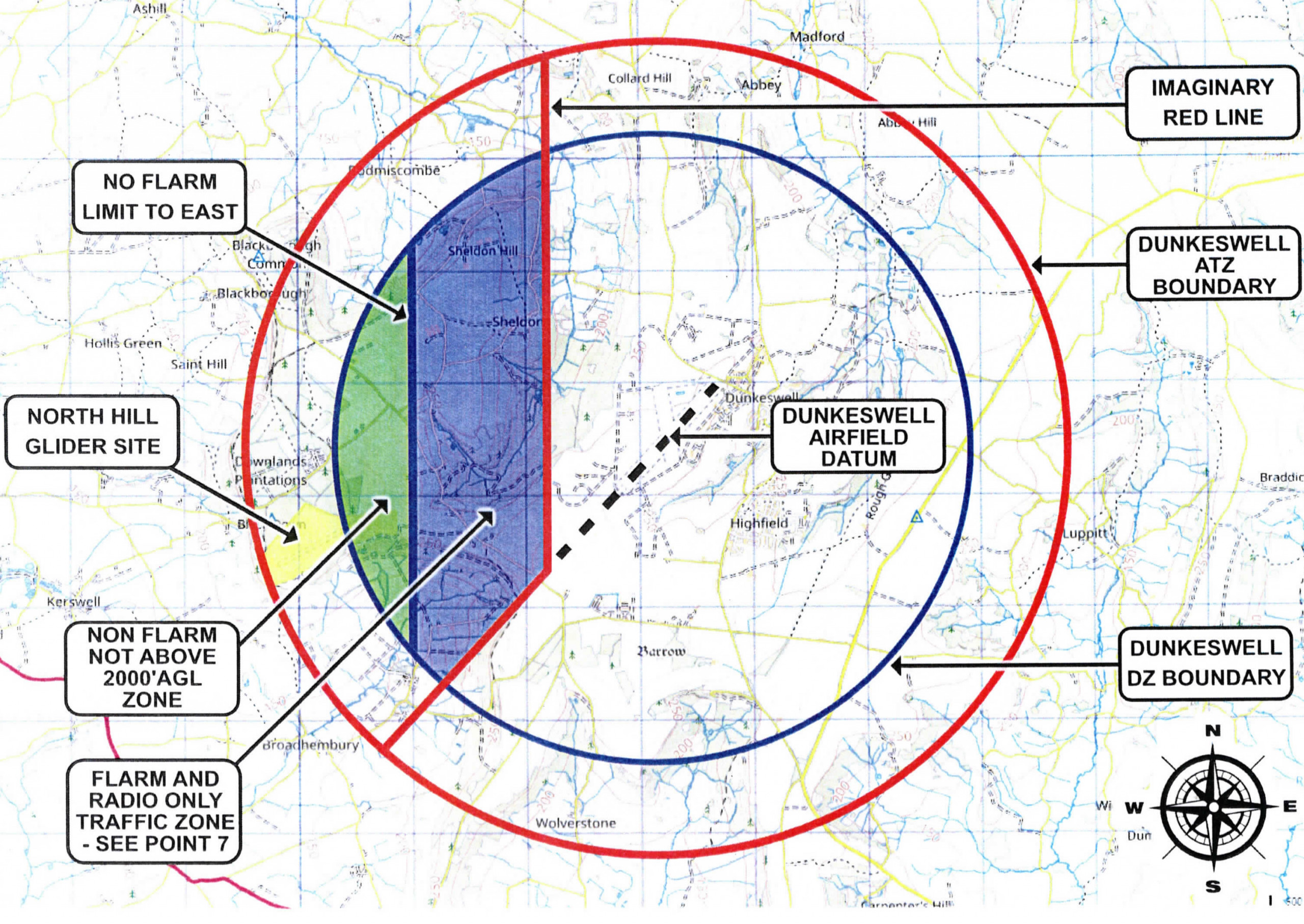
Devon and Somerset Gliding Club (DSGC) at North Hill operates within the ATZ of Dunkeswell airfield and partly within the drop zone of the parachuting organisation at Dunkeswell airfield.
A letter of agreement has been drawn up between DSGC and Air Westward to delegate airspace and operating procedures to DSGC within Dunkeswell ATZ. Within this LoA is also a Code of Practice drawn up between DSGC and Skydive Buzz to enable safe procedures between the two operations.
Dunkeswell Ground operates on: 123.480
Dunkeswell Parachuting operates on: 129.905 (same as North Hill)
Download the Dunkeswell ATZ (including the Code of Practice with Dunkeswell Parachuting – Skydive Southwest) Letter of Agreement
Download local map
Download the Dunkeswell Drone and Model Flying Letter of Agreement
Revised local airspace files are now available on ASSelect
Exeter airspace
Exeter airport is 9 nm (16 km), south-west of North Hill. It is marked as an aerodrome with 2.5nml radius ATZ andwith Instrument Approach Procedures (IAPs) outside controlled airspace. The ‘feathers’ are aligned along the extended centreline of the Instrument runways, and are not representative of the coverage area of the IAP associated with that runway. Pilots intending to fly within 10 miles of any part of the ‘IAP symbol’ are strongly advised to contact Exeter Radar.
Exeter Radar operates on 128.980
Under a Letter of Agreement (LOA) 2025 with Exeter ATC, North Hill Duty Instructor telephones Exeter ATC at the beginning of every flying day and informs them of gliding operations so that radio contact does not have to be made every flight.
Glider pilots should not cross the southern limiting line (A30 / railway line) without first calling Exeter Radar to advise of their location and intentions.
Yeovilton Local airspace
26 nm (50 km) ENE of North Hill is the Royal Naval Air Station (RNAS) at Yeovilton, and about half way is its satellite airfield at Merryfield, both are within the Yeovilton Area of Intense Aerial Activity (AIAA). The AIAA covers an area of almost 3000 square kilometers from the surface to 6000′, it stretches from the north coast of Somerset to the south coast of Dorset and from the eastern edge of the Blackdown Hills to Shaftsbury.
So any worthwhile cross countries to the east of North Hill are obviously going to be flown through the AIAA.
Whilst there is no legal requirement to have radio communication with Yeovilton, unless wishing to enter the ATZ, it is always wise to contact them if flying within, or near, the MATZ. They would also prefer to be contacted whilst you are flying through the AIAA.
Yeovilton LARS operates on: 127.355
Download a briefing presentation by Yeovilton ATC.
Airways
Berry Head CTA (previously Airway N864) runs roughly north-south with its eastern boundary above the western end of North Hill airfield, the base is FL65.
Berry Head CTA (previously Airway N862 runs parallel and to the east of N864, the base is FL105.
These airways are under the control of Cardiff Radar on: 119.155
Cardiff Airspace
There is a small area of Cardiff Control Terminal Area (CTA) below Airway N864, 5 nm from the north coast of Somerset, base 4500 ft, tops FL65. As it is Class D airspace, gliders may enter having contacted Cardiff Radar.
Cardiff Radar operates on: 128.855
Cardiff APP operates on: 119.155
North Hill Winch Launch permission
Download the CAA Winch launch permission